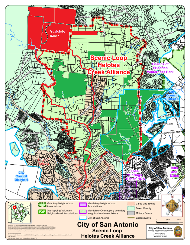
The developer who is looking to purchase Guajolote Ranch (~1160 acres) immediately adjacent to our neighborhoods northern border is proposing placing ~3000 new homes on that tract of land. Considering acreage required for the necessary infrastructure within the development, this would place between 4 and 5 homes per acre.
The Scenic Loop – Helotes Creek Alliance has signed on with the Greater Edwards Aquifer Alliance (GEAA) in request that SAWS Board decline Lennar Homes – Guajolote request for Water Utility Service.
Below is a list of items to inquire about and consider as this development progresses:
- Does the Bexar County / City of San Antonio planning departments still take the San Antonio North Sector Plan into consideration during platting? Innumerable deviations from the plan with this development.
- Why does SAWS have a CCN for water in a region where the property owners have no use for them? The CCN only benefits the Development Companies, the property owner provide for their own water and wastewater.
- What effect will 3000 new residential homes (~10,000) residents have on the rural roadways in the area?
- Why is this developer not being required to fund item #5 ($10M) on the AAMPO Strategic Transportation Plan’s unfunded roadway list?
- Considering the topology of Guajolote Ranch, how does the developer (Lennar Homes) plan to place 3000 homes on this tract? Change the topology?
- The creeks and dams in our neighborhood filled up with silt and TCEQ fines were issued to other developments north of our neighborhood. What will happen to our creeks and dams when the developer changes the topology of Guajolote Ranch?
- Is the developer considering an alternate route to Hwy 16 (Bandera Rd)? And will they consider extending Babcock Rd extension to Hwy 16 to prevent traffic through our already congested neighborhood?
Resources:
- Chimney Creek Neighborhood Letter – https://www.scenicloop.org/wp-content/uploads/GuajoloteRanchLetterFebruary2022-Google-Docs.pdf
- Copy of the Guajolote Utility Services Agreement – https://www.scenicloop.org/wp-content/uploads/R002662-USA-26994_Guajolote_Ranch_USAdraft_1-25-22.pdf
- Template Letter – https://www.scenicloop.org/wp-content/uploads/12-2-21-letter-CCreGuajolote.htm
- GEAA – https://aquiferalliance.org/2022/01/helotes-canyon-watersheds-future-at-stake-with-guajolote-tract-decision/
- GEAA Letter to CoSA – https://aquiferalliance.org/wp-content/uploads/2022/01/1-4-2022-CC-Guajolote-Amendments-1-1-1.pdf
- SA Report – https://sanantonioreport.org/groups-fight-to-limit-sewage-lines-over-edwards-recharge-zone/
- Express News Story – https://www.expressnews.com/news/local/article/SAWS-water-Guajolote-Ranch-16822681.php
- Express News – https://www.expressnews.com/news/local/article/SAWS-expansion-decisions-16778095.php
- SwRI Report (2020) – https://www.swri.org/press-release/impact-wastewater-systems-edwards-aquifer-hydrologic-computer-model
- San Antonio North Sector Plan – http://www.sanantonio.gov/Portals/0/Files/OMA/NorthSectorPlan20100730eCML.pdf
- Is this applicable in the City of San Antonio’s ETJ?
- Save Scenic Loop on Youtube – https://www.youtube.com/channel/UCSs1hx_7yvi7JYeBShegJ1Q
Timeline:
- 2022-02-01 –
- SAWS Board Meeting – https://player.vimeo.com/video/670835038
- 2022-01-13 – GEAA on OnTheRecord (fast forward 17:30) https://player.pbs.org/partnerplayer/9ZlKCONmYRjgSiFFY-GvdQ==/?topbar=false&autoplay=false&callsign=KLRN
- 2022-01-11 – SAWS Board Meeting (first 26 minutes) https://player.vimeo.com/video/663088253
- 2022-01-07 – AAMPO TAC (TBD) https://www.alamoareampo.org/Committees/TAC/
- 2021-12-22 – The City of Grey Forest voted and approved Resolution No. 2021-17R affirming their opposition to all sewer options except that of individual residential on-site septic systems and will be sending their resolution to the City of San Antonio and SAWS.
- 2021-12-07 – SAWS Board Meeting (fast forward to 04:00:00) https://player.vimeo.com/video/652620334
- 2021-11-02 – SAWS Board Meeting (fast forward to 02:42:00) https://player.vimeo.com/video/640051200
The following was presented to the SAWS Board during their November 2, 2021 meeting to present the options available to handle the sewage created from these ~3000 new homes. SAWS is to vote on the recommended option on February 1, 2022. Do you want to let them know your thoughts? Please send your comments to the SAWS Board directly. (template opposition letter linked above)
Before detailing the options presented, we would like to remind you of the objective set forward during the establishment of the “Scenic Loop – Helotes Creek Alliance” (referred to below as SL-HCA) bylaws:
- Maintain the status of the historic Scenic Loop Road from Hwy 16 (Bandera Rd) to Babcock Rd as a rural road.
- Keep the native tree canopy intact, and protected from the spread of Oak Wilt.
- Protect the visual, physical and aesthetic qualities of the existing Corridor.
- Support protection of the region’s historical and cultural integrity.
- Support protection and preservation of the region’s natural beauty and resources to include water, endemic, endangered species, viewshed and dark sky.
With that in mind, lets detail out each of the proposed options in order of our boards preference.
Our boards preference is in alignment with that of the Greater Edwards Aquifer Alliance (GEAA) and other environmental organizations; and is supported by scientific studies and reports.
Septic System (SL-HCA Preferred of 4 BAD Options)
- Aligns with all other residential on-site sewage facilities (OSSF) in the area including the neighboring Canyons of Scenic Loop and Cantera Hills neighborhoods.
- Bexar County minimum land requirements for septic systems (on-site sewage facilities) is 0.5 acres.
- This option would reduce the density of homes by nearly half, thus aligning more closely with the San Antonio North Sector Plan. Still there are concerns regarding adherence to the sector plan.
- Goal UTI-6.1 – Enhance communication with all water purveyors and the City and Counties on the proposed expansions of Certificates of Convenience and Necessity (CCNs) for sewer and water that is consistent with the Sector Land Use Plan
- Goal Hou-1.2 – Encourage compatible growth patterns and transitions of higher density residential along principal arterials and transit corridors that fit in with the existing residential character of the North Sector.
- Goal Hou-1.6 – Support the efforts to designate, preserve and enhance existing and future neighborhood conservation districts within the North Sector.
- Goal Hou-2.1 – Focus High Density Residential near activity centers.
- This option would also make it the responsibility of each individual home owner to ensure their septic is maintained.
- This option was also the recommendation of Greater Edwards Aquifer Alliance (GEAA).
- This option best supports the SL-HCA objectives #2, #3 and #5 above.
On-Site Wastewater Treatment Plant
- On-site Treatment Plant that discharges treated effluent on-site.
- No CCN (certificate of convenience and necessity) for sewer exists in or around this parcel and requires acquisition approval from the Texas Public Utility Commission, TCEQ and the City of San Antonio.
- Developer owned and maintained until development reaches some percentage of completion and then turned over to the neighborhoods HOA for ongoing long-term maintenance.
- This option only partially supports SL-HCA objective #5 above. Due to the density of development dark skies and viewshed protections are difficult to impossible to preserve.
- SAWS is including the following provisions in the Water Utility Services Agreement with Lennar Homes of Texas:
- The developer will set aside 50% of the project as open space
- The developer will restrict the site to 30% impervious cover
- The septic system will be an aerobic system to minimize impact to the Edwards Aquifer Contributing zone
- The wastewater treatment plant will meet all TCEQ standards for facilities discharging with 5 miles of the Edwards Aquifer Recharge Zone
- The developer will include increased treatment requirements to include advanced nutrient removal and effluent filtration
- The discharge permit will not be increased in capacity or modified to a different type permit in the future and will only serve the 1160 acre development
- The treatment plant effluent discharge location will be at least 1 mile upstream of any other property
- The plant will be operated and managed by an A level wastewater operator
- Any irrigation use of the wastewater discharge will include soil supplementation to allow enough soil to properly absorb the effluent
Multiple new Lift Stations
- This option is not being entertained by SAWS.
Oversized Gravity Sewer Main
- This option is not being entertained by SAWS.
Howdy, I placed signs at Scenic Loop and Babcock against this development. On 5/24/22, those signs have been blacked out by someone…
Thank you for pointing out the enviroimpact. I was concentrated on the increased traffic.
Thank you for making me aware of this travesty.
The comment section is open.
Thank you to all those who attended our March 9th in person meeting and sharing your perspectives with all of our neighbors.